



Engineering · Geological and geotechnical investigation
Before foundations are designed, you need to know what is under the site. A geological-engineering investigation shows the layers of soil and rock, the groundwater level and the physical and mechanical properties of each layer, so the structural engineer designs the foundations on measured data rather than assumptions.
SARP & LAB carries out the investigation from start to finish with its own team and equipment: drilling with our own rig, field tests, the MASW geophysical survey and sample testing in our ISO/IEC 17025-accredited laboratory. Everything comes together in one geological, geotechnical and seismic report for the same site.
When you need a geological survey
- New buildings. Under VKM no. 1162 of 24.12.2020, the building permit needs a geological-engineering study and a seismic assessment of the site. We prepare both for the same site.
- Foundation design. The structural engineer needs the soil parameters (cohesion, friction angle, compressibility) to choose the foundation type and calculate settlement.
- Roads, yards and fills. Soil classification, Proctor and CBR for design, then compaction control on every layer.
- Existing buildings. Extra storeys, a change of use or cracking from foundation settlement all call for knowing the ground the building stands on.
What the investigation includes
The programme is tailored to the structure and the local geology. A full investigation has these parts:
| Part | Carried out by | What it gives you |
|---|---|---|
| Desk study | SARP | Regional geology and tectonics, maps and previous studies for the area. |
| Setting out and safety | SARP | GPS setting out, drone survey and a ground-penetrating radar (GPR) scan of every borehole position for buried services. |
| Boreholes and sampling | SARP, with our own drilling rig and crew | Rotary boreholes with continuous Ø100 mm coring, SPT tests, disturbed and undisturbed samples and a log of every borehole. |
| Groundwater | SARP | Water level, monitored piezometers and groundwater chemistry for concrete aggressiveness (EN 206). |
| Laboratory tests | SARP laboratory, ISO/IEC 17025-accredited | Soil classification, shear strength, compressibility and rock properties. |
| Field tests | SARP, accredited on site | Deformation modulus with static and dynamic plate tests, DCP, vane shear strength and sand-cone density. |
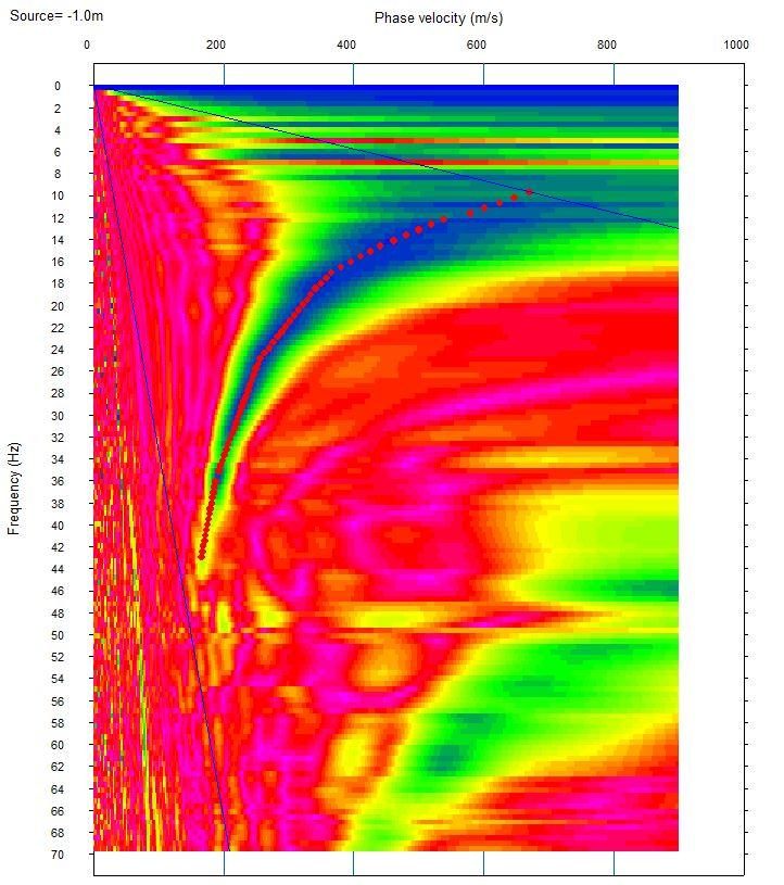
| MASW geophysics | SARP | Shear-wave velocity profile Vs with depth, Vs,30 and the Eurocode 8 ground type. |
| Seismic study | SARP | Seismic hazard and design spectra to EC8 and KTP-N2-89. See Seismic Assessment. |
How the fieldwork is done
Fieldwork follows BS 5930:2015 and EN 1997-2. The programme, with the number, position and depth of the boreholes, is sent to you for approval before mobilisation.
Desk study and safety
- Review of the geological, engineering-geological and hydrogeological maps, previous studies in the area and the architectural project.
- GPS setting out of the positions and survey of coordinates and levels in the KRGJSH-2010 system.
- Ground-penetrating radar (GPR) scan of every borehole position and a check for overhead lines, to protect the crew and neighbouring services.
- A site-specific risk assessment and method statement (RAMS), a fenced work area and personal protective equipment.
Drilling and sampling
- Rotary boreholes with continuous Ø100 mm coring, to BS 5930 and EN ISO 22475-1.
- Core logging on site by an engineering geologist to EN ISO 14688 and 14689; cores are boxed, labelled and photographed.
- SPT tests to EN ISO 22476-3 every 1.5 m in soils and at every change of stratum.
- Undisturbed samples in cohesive soils (Category A, Class 1–2 to EN ISO 22475-1), sealed immediately to keep their moisture and structure.
- Boreholes backfilled with cement-bentonite grout and the site reinstated.
Groundwater
- Water strikes and water levels recorded at the start and end of every working day.
- Ø50 mm standpipe piezometers with filter, sand pack and bentonite seal, with monitoring visits (e.g. after 24 hours, 7 and 30 days) for the design water level.
- Groundwater chemistry (pH, sulfates, chlorides, magnesium, ammonium, aggressive CO₂) to EN 206, Table 2, for the concrete exposure class.
Geophysics
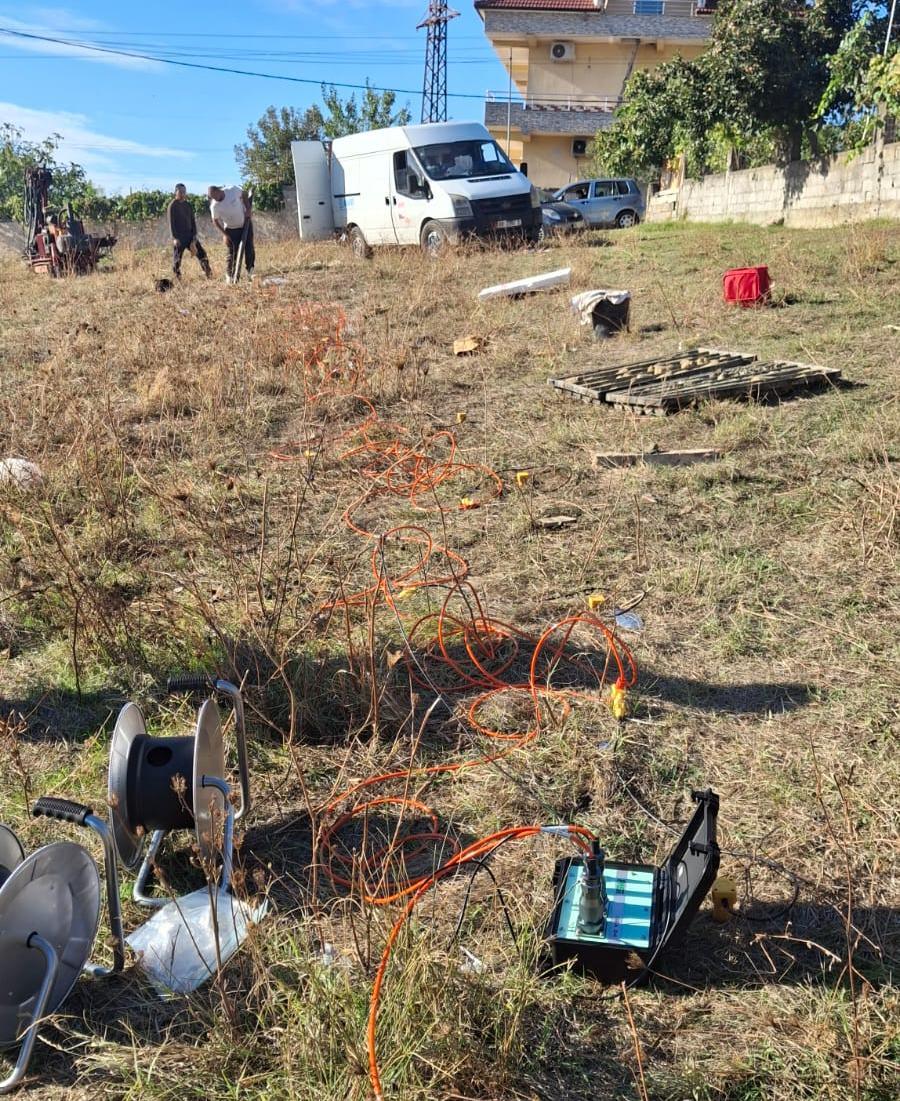
- MASW seismic lines with a 24-channel seismograph and 4.5 Hz geophones, for the Vs profile with depth and Vs,30.
- Where needed, HVSR microtremor measurements for the fundamental period of the ground.
How deep should the boreholes go?
Depth is set to EN 1997-2, Annex B.3, from the type and size of the foundation. For a raft foundation, for example, the investigation should reach at least 1.5 times the foundation width below foundation level, or a competent stratum of proven thickness.
With basements the foundation level is several metres below ground, so the boreholes need to go deeper. If a competent stratum is not reached, the depth is extended on site in agreement with the client. The MASW Vs profile to 30 m shows whether there are weaker layers below the drilled zone, but it does not replace drilling.
Ground conditions on the Durrës coast
Along the Durrës coast (Kallm, Plazh, Golem) you can usually expect loose Quaternary deposits (sands, silty sands, soft clays), shallow groundwater with chlorides and sulfates, and high seismicity: this is the area of the 26.11.2019 earthquake (Mw 6.4). For these sites our programme includes:
- SPT tests every 1.5 m for the density of the sands;
- piezometers and groundwater-level monitoring;
- water and soil chemistry for concrete aggressiveness;
- liquefaction assessment of saturated sands to EN 1998-5.
Accredited soil and rock tests
The tests below are within our laboratory’s accreditation scope (DPA certificate LT 069). Standards, ranges and sample requirements are on the Geotechnical Testing and Natural Rock Testing pages.
Soil: in the laboratory
- Natural water content and bulk density
- Particle size distribution by sieving and hydrometer
- Atterberg limits (liquid and plastic limits)
- Proctor: maximum dry density and optimum moisture
- California Bearing Ratio (CBR)
- Direct shear: cohesion and friction angle
- One-dimensional consolidation (oedometer)
- Indirect tensile strength of stabilised mixtures
Soil on site, and rock
- Static (Ev1/Ev2) and dynamic (Evd) plate load tests
- Dynamic cone penetrometer (DCP)
- Undrained shear strength with a portable vane
- In-place density by sand cone
- Rock: uniaxial compressive strength
- Rock: real and apparent density and open porosity
- Rock: water absorption and natural water content
Typical laboratory programme for a foundation study
The final programme is set once the samples have been described. The accredited tests are the ones listed above; for any other test the report states the standard used.
| Test | Reference standard |
|---|---|
| Natural water content | EN ISO 17892-1 / ASTM D2216 |
| Bulk density | EN ISO 17892-2 |
| Particle density | EN ISO 17892-3 |
| Particle size distribution (sieve and hydrometer) | EN ISO 17892-4 / ASTM D7928 |
| Atterberg limits | EN ISO 17892-12 / ASTM D4318 |
| Direct shear (consolidated, drained) | EN ISO 17892-10 / ASTM D3080 |
| Oedometer, with swelling pressure where needed | EN ISO 17892-5 / ASTM D2435 |
| Unconfined compressive strength of soil or rock | EN ISO 17892-7 / ISRM |
| Soil chemistry (sulfates, chlorides, pH) | BS 1377-3 / BRE SD1 |
| Groundwater chemistry | EN 206, Table 2 |
| Where needed: UU / CU triaxial | EN ISO 17892-8 / -9 |
What you receive: two coordinated reports
For the same site we deliver two reports in Albanian (English on request), in PDF and Word, signed and stamped.
Geological-engineering report (BS 5930, EN 1997-2)
- A plan of the investigation points and the geological and hydrogeological maps of the area.
- Regional geology, tectonics and hydrogeology of the site.
- Borehole logs, cross-sections and stratigraphic correlation, core photographs.
- Laboratory results and certificates; accredited tests carry the accreditation mark.
- The groundwater level and its aggressiveness to concrete.
- A ground model with characteristic parameters for every stratum: c′, φ′, deformation modulus, unit weight, allowable bearing pressure.
- Recommendations for foundations, settlement, excavations and slope support, drainage and the concrete exposure class (EN 206).
Engineering-seismological study (EN 1998-1, KTP-N2-89)
- Seismicity and tectonics of the area.
- The MASW profile: Vs with depth and Vs,30.
- Ground type to EC8 and KTP-N2-89.
- Seismic hazard for 95- and 475-year return periods.
- Horizontal and vertical elastic spectra and the site period.
- Liquefaction assessment to EN 1998-5 where the ground calls for it.
Borehole and laboratory data are also delivered digitally (AGS4 or Excel), so the designer can use them directly. The draft reports are sent to you for comments before final issue.
Standards we follow
| Area | Standards |
|---|---|
| Investigation and description | BS 5930:2015+A1:2020; EN ISO 14688-1/-2:2018; EN ISO 14689:2018 |
| Sampling and groundwater | EN ISO 22475-1; EN ISO 22282 |
| Field tests | EN ISO 22476-3 (SPT); EN ISO 22476-1 (CPTu) |
| Laboratory tests | EN ISO 17892 series; ASTM; BS 1377 |
| Geotechnical design | EN 1997-1 and EN 1997-2 (Eurocode 7) |
| Seismic design | EN 1998-1 and EN 1998-5 (Eurocode 8); KTP-N2-89 |
| Concrete aggressiveness | EN 206 / SSH EN 206; BRE SD1 |
| Legal basis | VKM no. 1162 of 24.12.2020 |
Additional services when needed
- CPTu tests and boreholes deeper than 30 m.
- Lefranc permeability tests (EN ISO 22282).
- Plate load tests on site.
- Long-term groundwater monitoring.
- Geological supervision during excavation and acceptance of the foundation formation.
- Technical support for the designer after the report is issued.
How we work
Send us the details
The location or site plan, storeys above and below ground, the expected foundation type and site access.
Desk study and programme
We review the maps and studies for the area and send you the programme for approval: boreholes, depths, tests and MASW lines.
Fieldwork
Drilling, SPT, sampling, piezometers and MASW. During the works you receive a short daily progress report.
Laboratory
Sample testing in our laboratory at Vrrin, Durrës–Tirana motorway, km 29.
Draft and final report
A draft for your comments, then the signed reports, coordinated with the seismic study.
Frequently asked questions
What is the difference between a geological and a seismic study?
The geological-engineering study describes the layers of the ground and their properties for foundation design. The seismic study defines the seismic action at the site: Vs,30, the ground type and the design spectra. A new building usually needs both; we carry them out for the same site and coordinate them in one report.
How many boreholes does my site need?
It depends on the footprint and height of the building, the basements and the local geology. We propose the programme once we have seen the location and the project.
How deep will the boreholes be?
Under EN 1997-2 the depth depends on the type, width and level of the foundation. For a raft, at least 1.5 times the foundation width below foundation level is recommended, or down to a competent stratum. We propose the exact depth in the investigation programme.
Do you drill the boreholes yourselves?
Yes. We do everything in-house: drilling with our own rig and crew, field tests, MASW geophysics, testing in our accredited laboratory and the report. You have one point of contact from the programme to the final report.
Are the tests accredited?
Yes. The soil and rock tests listed on this page are within our laboratory’s ISO/IEC 17025 accreditation scope (DPA certificate LT 069, valid to 07.06.2029). For any other test the report states the standard used.
Do you also investigate roads and fills?
Yes. For roads and yards we carry out soil classification, Proctor and CBR for design, then compaction control on every layer with plate tests, sand cone and DCP.
Why is the water level checked again after drilling?
Water is used during drilling to cool the bit, and this can mask groundwater strikes. That is why the level is checked again after 24 hours, and for design preferably with piezometers and several monitoring visits.
Is a liquefaction assessment needed?
In loose saturated sands, such as on the Durrës coast, yes. We assess it to EN 1998-5 from the SPT results, grading and water level, and the result is given in the seismic study.
What language and format is the report in?
Albanian, and English on request, in PDF and Word, signed and stamped. Borehole and laboratory data are also supplied in AGS4 or Excel.
Related services
Planning a new building? Send us the location and the project. We’ll propose the investigation programme and the price.